Exploring for Radioisotopes
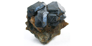
Uranium typically occurs in highest concentrations in the mineral uraninite, which is also called pitchblende because of its black color. In a natural, unrefined state, uranium usually exists chemically bound to oxygen as Triuranium octoxide (U3O8), the most stable, and least radioactive form of uranium oxide.
Uranium exploration is very similar to other forms of mineral prospecting with the exception of specialized instruments to detect radioactive isotopes.
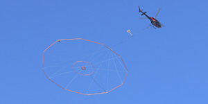
The Geiger counter was the original radiation detector used in the field in the 1930s. The first transportable Geiger–Müller counter (weighing 25 kg) was constructed in 1932 at the University of British Columbia. Using airborne detectors for radioactive prospecting was first proposed by a geophysicist named G.C. Ridland, in 1943. In 1947 Eldorado Mining and Refining Limited (now Cameco Corporation) conducted the earliest recorded trial of an airborne radiation detector. In the early years of uranium exploration many of the deposits located close to the surface were discovered using these technologies.
Today, uranium exploration is more complicated since the remaining deposits are deep beneath the surface, therefore blind to direct detection. Advanced technologies, such as geophysical surveys, satellite imagery and geochemical analysis, processed using specialized computer programs and modelling techniques, are utilized in targeting for these deposits.
Modern airborne geophysical survey techniques can detect geological features associated with uranium mineralization to depths of over one kilometer. These techniques include high-resolution electromagnetic surveys, used to detect graphitic structural zones, a major geological marker for uranium mineralization. The resolution of airborne data has also improved – approaching that of ground surveys – in some cases allowing direct targeting from airborne results.
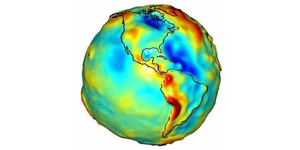
High-resolution magnetic and gravity surveys are used to assist in the understanding of the geology at depth and map major structural zones. Because the mass (or density) and magnetic mineral content of various rock formations are different, slight variations in the gravity and magnetic fields are observed on surface, giving insights into the geology and structure of the Earth. Utilizing changes in the density and porosity of rocks seismic surveys are used to directly image unconformities and structure at depth. Despite limited depth penetration, airborne gamma-ray spectrometry is still considered one of the leading techniques for uranium prospecting, with worldwide applications for geological mapping, mineral exploration & environmental monitoring.
Geologists typically seek unconformity-related deposits, which are found between younger and older rocks, and represent a gap in the geological record. These types of deposits provide all of the uranium production from Canada and a major proportion of Australia’s resources.
In the Athabasca Basin of northern Saskatchewan, these deposits are associated with quartz sandstones and conglomerates filling an oval-shaped basin that is about 1.5 km deep at its centre. Uranium deposits in the basin tend to be extremely high-grade (some average 18% U3O8), but are difficult to find because of their depth and relatively small size.
Exploration is not finished once a likely deposit location is discovered.
Next steps include on the ground evaluation, targeting and sampling to determine if the amount of uranium present is economic to extract. Concentrations of uranium that are economically viable to mine are considered ore and range from about 1,000 up to 200,000 parts per million uranium.
After targets have been identified the next stage of exploration is core sample drilling. Core samples are taken from the target location until a deposit is located or the anomaly has been explained. A significant advance in modern drilling techniques is the use of directional drilling, which allows several intersections to be made from a single pilot hole, reducing drilling costs and improving target precision considerably.
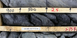
Once core samples have been extracted they are carefully photographed, catalogued and evaluated by geologists in the field. Selected samples of the core are then transported to labs for further testing to determine mineral composition and uranium concentrations.
Complex and sophisticated data management and modelling tools are now a routine part of the modern geologist’s toolkit. Throughout the entire exploration process, data is meticulously gathered and input into data systems for further assessment, mapping and modeling.
The final decision to eventually mine a deposit depends on many factors including market prices, ore concentrations, the cost and method of extracting the ore, location of the deposit, as well as social and environmental considerations.
The largest deposits of ore-grade uranium are found in Australia, Kazakhstan and Canada. The only known high-grade deposits are found in Canada.
